
"The buoy" near Kauai predicting Utah Pow

As a Meteorologist, I take my forecasting seriously. After getting my Bachelor of Science in Meteorology, I went on to TV as a Broadcast Meteorologist. Moral of the story, I've been studying the weather forever it seems. One day, friends told me about "The Buoy." What is that? Well, it is a buoy that has its own Facebook page managed by an avid skier and supporter of Ski Utah, Mike. Mike tells us this buoy can predict when big pow hits Utah! If you like the sound of that find more info here!
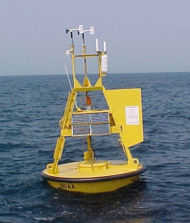
A Little background first. The Buoy is a 3-meter discus buoy that floats out in the Pacific 190 NM Northwest of Kauai. The National Oceanic and Atmospheric Administration (NOAA) has a whole network of buoys all over the oceans in the world that track weather and ocean conditions. They measure the wind, barometric pressure, air and water temperature, and wave heights since it sits on the ocean's surface. These observations are taken from the whole network of buoys all over the world and help when making weather predictions and the tracking of storms and also with the measurement of the water temp, can help predict El Nino periods. Moored buoys-anchored have been used since 1951. These whole wave dynamics is a bit above my background in Meteorology, but keeping it simple is basically looking for high wave heights in a weekly/monthly period.
When getting in touch with Mike on the background of The Buoy, he said surfers have been using buoys for years to track storms and follow the big surf. Keep in mind, when areas of low pressure swing through, there is a jump of the wave height/swell. Here is the link to this particular buoy, 51101. Mike mentions that he has been tracking this particular buoys for over 10 years and started to find a correlation between the huge height swells and Utah's weather! His findings are this:
After a spike in the buoy's wave height, there will be a good snow storm in Utah 2 weeks later. My response? How can this be? I joined The Buoy on Facebook and started reading some of the summary's and the prediction. Here are some of the buoy "Pops" as Mike calls them which is when the wave height pops up quite high and then he does his "2 weeks until a Utah storm."
I looked back over the past "buoy pops" and indeed, each pop did correlate to Utah storms two weeks later. When I say "good storm" I'm meaning, at least, a foot of snow:
Pop for Jan 16/17: Good storm 14-16
Pop for Jan 18/19: Good storm on the 18th
Pop for Jan 29th: Good storm on 30th
Pop for Feb 3rd: Storm 4-6
Pop Feb 22nd: Small storm 22nd
We have been in a quiet period since the beginning of February with a ridge of high pressure sitting over us. There have been several "pops" toward the end of February and into the early part of March. The problem with high-pressure ridges is they are hard to break down. It takes sometimes several storms to move into the ridge, break apart and fizzle before the entire pattern breaks down. Knowing this and seeing these huge "pops" but then watching them amount to a small storm shows it isn't an exact science. (this is good for my job security)
With that said, it looks like these latest buoy pops are going to bring us some snow! The pattern is changing in Utah. Below is the latest buoy pop for March 10/11:

This shows the latest prediction of the pattern change:
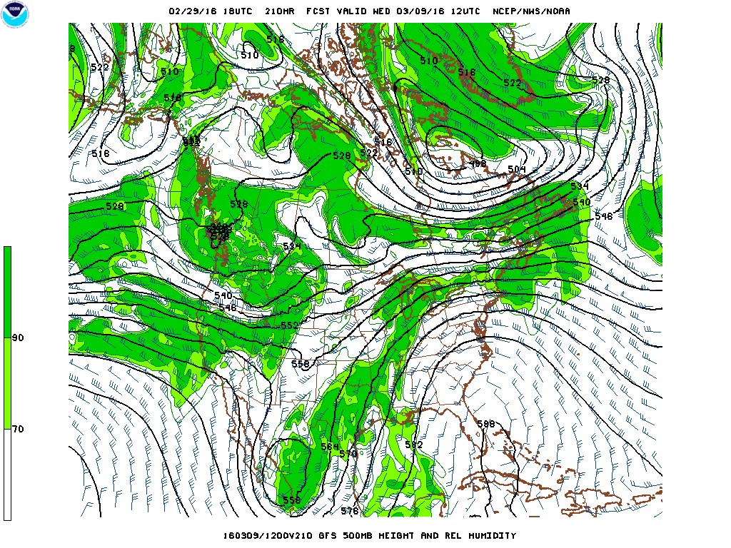
All that green - moisture - moving into Utah shows the pattern change we've been waiting for. Those storms that have given "big buoy pops" and then haven't done a lot have banged up the ridge enough to finally bring the change. As of right now, it looks like March 7th will start to bring moisture in and then it just continues with the more western flow heading in by the 9th. This looks to bring unsettled weather right into the middle of March. Keeping that in mind, March is normally a very stormy month in Utah so it is a great time to get some big snow for your spring break trip.
I will still always look at computer models and do my own forecasting, but will be real curious to see how this whole buoy business does as well. I would also keep looking at The National Weather Service and Wasatch Snow Forecast which contribute to Ski Utah snow reporting page. If you'd like to follow The Buoy, go into your Facebook page and search The Buoy. Put in a friend request and away you go! Mike wanted to point out he is a great fan of Ski Utah and loves to get out as much as possible during those big powder days.
Thanks, Mike!
comments
More From Mountain Mama


Next Story
Partners In Promoting Utah Powder


2 Comments
Colin Burns \ 9.2 years ago
Thanks for sharing this! How cool that a buoy so far away could predict the powder on the slopes! Makes me wonder if there are buoys out there that could give us a heads up for some other mountains around the country. Definitely liking The Buoy on Facebook and keeping an eye on its progress. Did the Valentine's snow pan out?
Luke Web Admin \ 9.2 years ago
come on Buoy prediction for Feb 7-8 & give me some Valentine's Day Pow Pow
Steven Spriggs \ 9.2 years ago
I agree I'll be at Park City/Canyons 12-17th, need some blower!