
Utah Winter Ski Season Kicks Off with Significant Thanksgiving Weekend Storm

Last year we had a notoriously slow start to the winter season here in Utah. Ultimately, it turned into what most locals would consider a down year. With that said, we still saw upwards of 300” of snowfall and numerous deep powder days:
As I’ve always said, a “bad” winter in Utah still offers better skiing than virtually anywhere else in the world – a statement that is confirmed by our legitimate boast to have “The Greatest Snow on Earth.”
Still, because of last year, nerves were high here in Utah at the beginning of November 2018 when it seemed we were destined for a repeat situation. After encouraging fall storms in early October, Utah then fell under the influence of a high-pressure ridge for much of late October and early November. Unlike 2017, however, temperatures this year have been cold. This has allowed local resorts to maintain the snow that has fallen as well as supplement that with man-made snow as well. Because of this, Brighton was able to open earlier than expected and Snowbasin Resort had their earliest opening in the resort’s history! Down south, Brian Head is also open. Park City Mountain and Alta Ski Area are scheduled to open on November 21st and 23rd respectively. For a full updated list of opening dates, click here.
A couple weeks ago, signs started to appear that a pattern change could be possible around the Thanksgiving. As we’ve approached the holiday, forecast models have latched on to the idea of a storm cycle that will likely bring significant snowfall totals to the mountains of Utah from Thanksgiving Day through the holiday weekend. The ridge of high pressure over the desert southwest which has kept our area from receiving significant storms will be replaced with a trough of low pressure starting on Thanksgiving Day. This trough will allow two storms to enter the region. The first storm on Thanksgiving will bring moderate snowfall amounts to the mountains of Utah. The second storm, which will impact the area Friday thru Saturday, is more significant and could bring more than 2 FEET of snow to the Wasatch Mountains of Northern Utah.
As of midday Tuesday, November 20th, the latest GFS model has the following snowfall amounts forecasted for Utah:
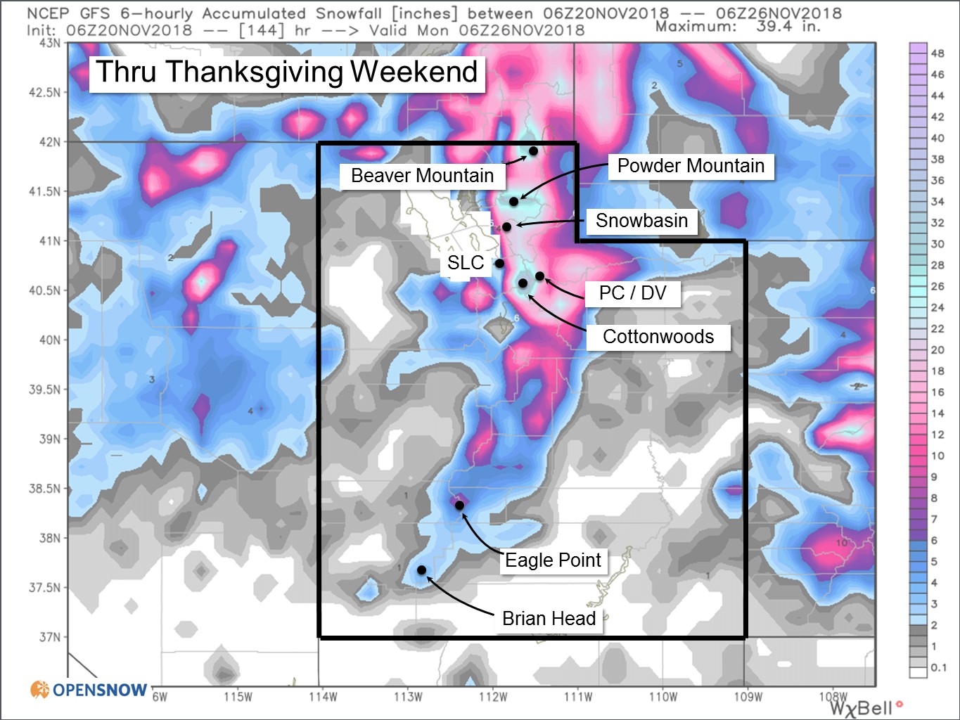
The heaviest snow will be in the northern half of the state where 1-2 feet is likely. Favored areas such as Little and Big Cottonwood Canyons (Snowbird, Alta, Brighton, Solitude) will likely see 3-day totals in excess of 2 FEET!
For reference, last year at Alta Ski Area (Utah’s snowiest ski area) we did not see our first storm of more than 2 feet until January 20-22, 2018. In fact, we only saw 4 storms of 2 feet or more all last winter. As you can tell, this is a tremendous boost for skiers and snowboarders in Utah hoping to build an early base and score deep November powder.
In meteorology and climate forecasting, we often look to analog years. These are years in which oceanic or atmospheric conditions were similar to what we see currently. We only have to go back to 2016 to find a similar analog year. In November 2016, we also had a slow start to the month of November, but similarly, the last 10 days of that month were extremely snowy. Utah ended up having one of its snowiest winter seasons in recent memory in 2016-17. While it’s difficult to say whether or not that will happen again, we can at least be excited that Utah has a history of coming on strong after slow starts to the month of November.
It appears as if we will see a break in the action after the weekend, but signs are starting to point to a return to snowy weather patterns at the end of November and beginning of December. You can check the latest forecast developments all winter long using the Utah Daily Snow page of OpenSnow.com.
Words by Evan Thayer
Words by Evan Thayer
Partners In Promoting Utah Powder


comments
Leave Your Comment