The season is now winding down, and most Utah resorts are no longer spinning lifts. Every year, we like to look back on the season and see how we did from a snowfall metrics standpoint. How did this year’s snowpack compare with some of Utah’s recent monster snowfall seasons? And how did we do in comparison to normal?
First, let us remind ourselves what we knew coming into this season. As winter got underway, the Pacific Ocean was in a moderate La Nina state. What did that mean for Utah? Very little, to be honest. The ENSO (El Nino/La Nina) Cycle has little correlation to Utah snowfall. We can easily see both good and bad years on each end of the spectrum. At best, we can perhaps say that it ever-so-slightly loads the odds in the favor of areas at higher latitudes. For example, La Nina generally favors areas farther north in the western US, so we expected that perhaps they would stand a better chance for generous snowfall this year. Such was the case in Utah, where we suspected that perhaps Northern Utah would be more likely to do better relative to normal than southern Utah. It should also be noted that three of the past four seasons in Utah have seen statewide snowpacks above normal, so we had a good run of luck coming into the season.
Now that we have established our status entering the season, we can dive into the data and see what actually did occur…
For the purposes of this blog, I am going to use the Snotel site in Little Cottonwood Canyon as a general guide to our season. Why that site? Because it would take me forever to break down every individual location and Little Cottonwood Canyon is one of the snowiest locations in the state. It also has reliable data and is centrally located to eight of the state's 15 resorts. Here is a detailed breakdown of the snowpack at this site this season: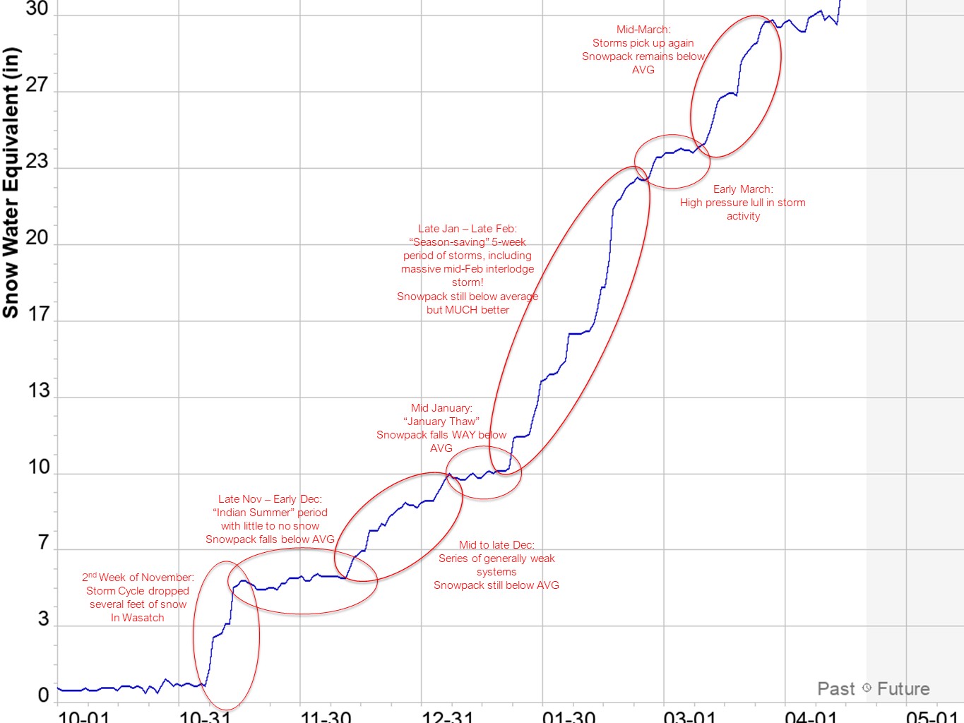
As you can see, I have annotated the snowpack graph to reflect some of the notable periods of dry weather and then some of the more significant storm cycles during the season. We had an auspicious start to the 2020–21 ski season in Utah with a large storm cycle in mid-November that built an adequate base for resorts to open. Unfortunately, we then saw an extended period of dry weather for the second half of November into early December, which caused us to fall below normal snowpack. Luckily, the storms did start returning around the holiday season. However, they were generally smaller systems with only light refreshes of the snowpack. As we flipped the calendar to 2021, our snowpack was running noticeably below normal: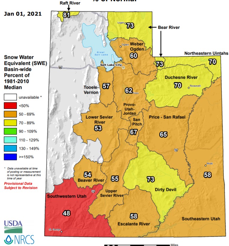
While there was enough snow that resorts were able to open terrain, powder hounds were left frustrated that Utah was not quite living up to its stellar reputation of delivering powder day after powder day. That all changed around the third week of January when the overall pattern finally flipped to one that was more conducive to significant storms.
In one month, the Utah snowpack improved dramatically from well-below normal to close to normal: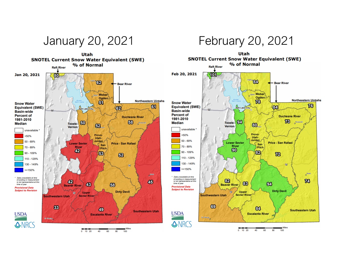
This included a mega-storm cycle that delivered 65” of snow in two days and 100” of snow in five days to parts of the Wasatch Mountains, leading to a legendary, record-breaking interlodge period at Alta Ski Area and Snowbird in Little Cottonwood Canyon. Looking back now, we can definitively say that the five-week period from the last week of January thru the month of February was the best skiing of the season here in Utah – a stretch of powder days that left locals and visitors alike smiling and begging for more. It also likely helped “save” our seasonal snowpack numbers.
In March and April, we continued to see frequent storms that maintained the snowpack and offered additional powder days. In fact, some of the best powder days of the season were as late as mid-April.
Here is the statewide average snowpack from over 80 locations:
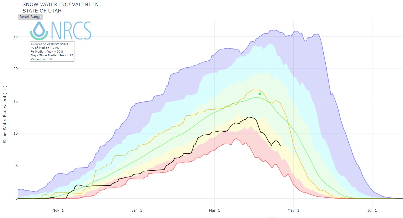
This year (black line) saw a peak median snowpack that was approximately 80% of the average year’s median peak (green line). We fell short of last year (gold line), but we were substantially ahead of the least snowy season (red line). While this may not have been an ideal year snowfall-wise, Utah proved that even after a slow start, a substantial comeback was possible. We ended up with a season that was somewhat close to normal, which is impressive, considering Utah’s normal is such a high bar. In fact, we have seen seasonal snowfall totals as high as 480 inches and counting. While we may not quite reach the lofty standards of our typical 500+ inches, it is still an impressive achievement.
As for next year, who knows? Maybe Old Man Winter will make up for this year’s slightly below normal year with another season to remember…We can dream, right?