words by Evan Thayer
Twelve years ago, a much younger version of me wrote a similar Ski Utah blog about the potential for an impending El Niño event for the then-upcoming 2014–15 ski season. Ironically, the blog ended up being a season premature. While we did technically see an El Niño in 2014–15, it was the next winter (2015–16) that developed into a much stronger “super” El Niño event. Even more ironically still, despite the hype, neither season was particularly memorable from a snowfall-relative-to-average standpoint. Since then, El Niño has largely ghosted us, come back weak, come back moderate; eventually, he came back to give us 2023–24's respectable-but-unspectacular season — generally acting like an ex who can't commit to a pattern. Well, buckle up, because all indications are that El Niño is finally ready to commit for the 2026–27 season, and according to NOAA, this time he's not messing around.
If you've never taken a meteorology class and your only exposure to El Niño is a vague memory of a Chris Farley SNL sketch, you're not alone. Most people know El Niño is a "weather thing," and can maybe recall that it has a shy sibling named La Niña, but otherwise treat it like a rumor that circulates every few years at the base of the lift. So let's actually break down what's happening this time, because it's a bigger deal than usual.
What Is El Niño, Again?
El Niño is one half of ENSO (El Niño-Southern Oscillation), the ocean-atmosphere cycle that quietly runs a lot of the world's weather from a stretch of the equatorial Pacific off the coast of South America, called the Niño 3.4 region. When the sea surface temperature there runs at least 0.5°C above average for a sustained period, meteorologists call it El Niño. When it runs cold, that's La Niña. Everything in between is the meteorological equivalent of a shrug, officially termed "ENSO-neutral."
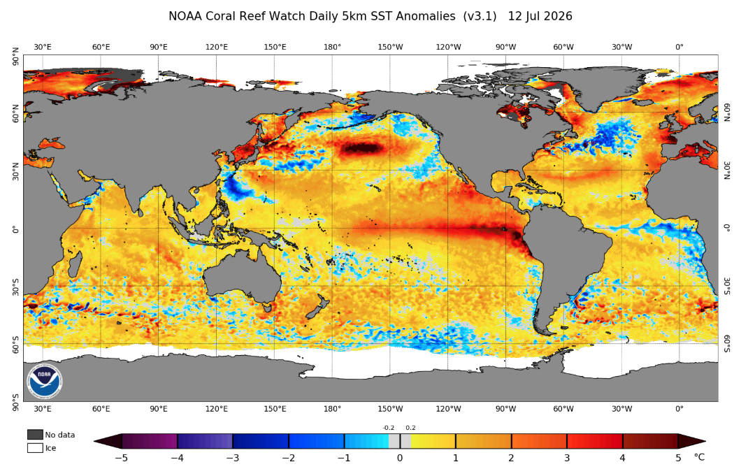
It sounds small. A patch of the Pacific being a degree or two warmer than usual doesn't seem like it should matter to anyone who isn't a fish. But that warm water reshapes the jet stream, which reshapes where storms go, which is the only part of this article that actually matters to skiers.
Where Do We Stand for 2026–27?
Here's the part that separates this write-up from every other "El Niño is coming, maybe" post you've read before: it's not a maybe. NOAA's Climate Prediction Center has already issued a formal El Niño Advisory. As of their July 2026 update, the Niño 3.4 index sat at +1.2°C:
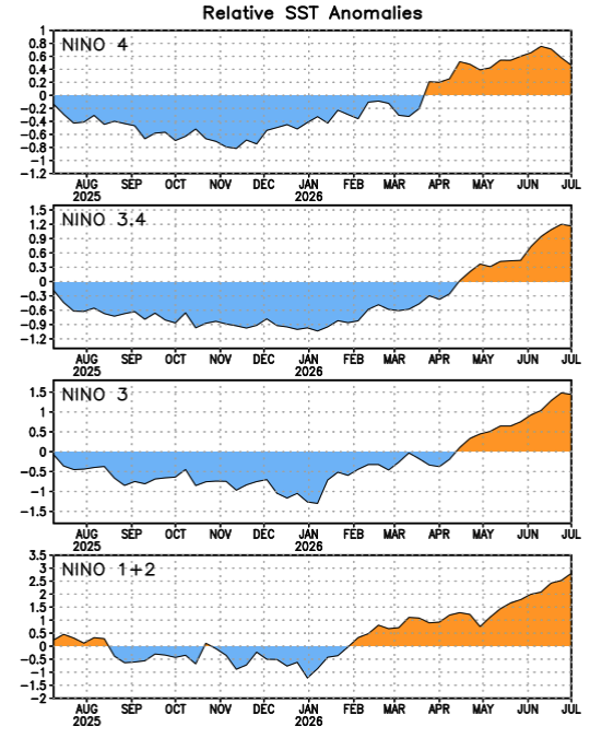
This is comfortably past the "is this even El Niño" threshold, and forecasters are calling for it to keep strengthening through the end of the year.
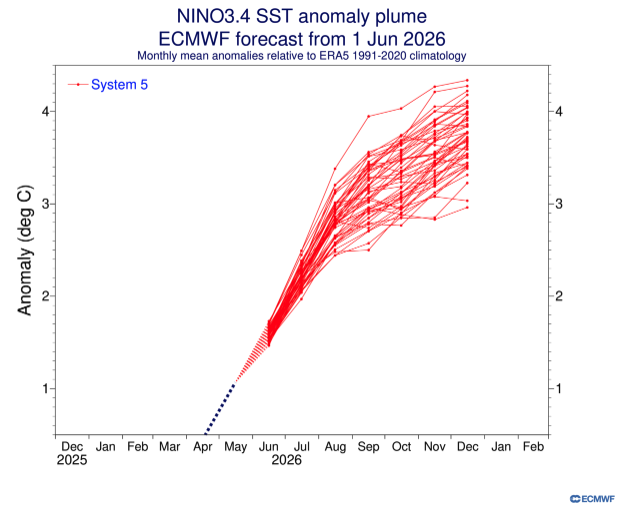
The eye-catching number: NOAA already puts the odds of an El Niño at 100% for the upcoming season, with the odds for a “very strong” El Niño currently sitting at 81% between October and December, which would put this event in the same tier as the biggest El Niño winters on record.
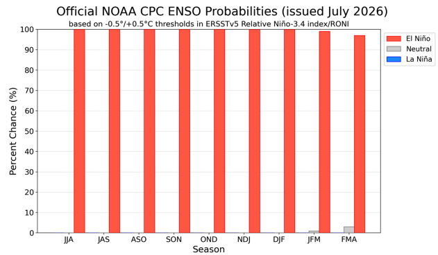
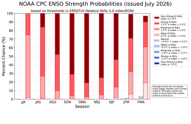
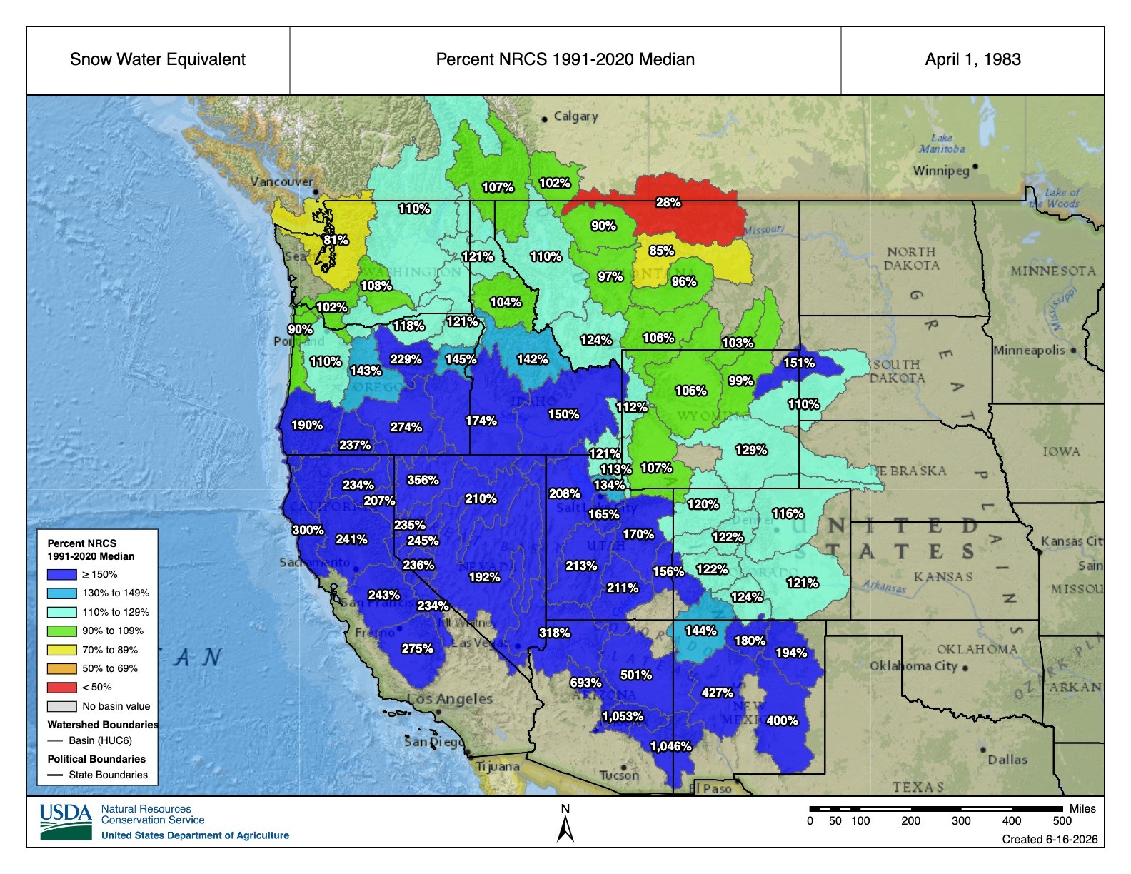
There's also a 97% chance El Niño sticks around through early spring 2027, so this isn't a phenomenon that's going to politely fade out before ski season even gets going. For context, "very strong" is the same category as the legendary winter of 1982–83, the one still talked about in hushed, reverent tones by anyone who skied the Cottonwoods that year and the one that, memorably, also flooded downtown Salt Lake City when all that snow melted at once. Great for turns, less great for State Street, which briefly became a river.
So What Does That Actually Mean for Skiing Here?
This is where El Niño has always had a bit of a messaging problem in Utah, because his reputation and his actual track record don't fully match. El Niño's signature move is shoving the storm track south, which is fantastic news if you live anywhere near St. George or Cedar City. Southern Utah tends to run above average for snowfall in El Niño winters, sometimes well above average.
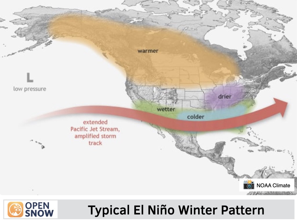
The Wasatch, on the other hand, has a more complicated relationship. Historically, strong El Niño winters have delivered Northern Utah snowpack that's average to a little below average, especially early in the season. The pattern tends to be a slow, cranky start in November and December, followed by the storm track sliding back north and things picking up from January through spring. That's more or less exactly what happened in 2023–24, our most recent meaningful El Niño winter: a quiet start, some grumbling on ski forums, and then Alta went on to rack up over 600 inches by the time it was done. So if opening month feels stingy this year, that's historically on-brand for El Niño, not a sign anything is broken.
Given that this year's event is trending toward "very strong" rather than "moderate," there's a real argument for optimism beyond the historical average. The strongest El Niño on record, 1982–83, didn't play by the "meh for the Wasatch" rulebook at all — the Cottonwoods reportedly picked up 800 to 900 inches that season, which, until 2022–23, was often cited as the snowiest winter Utah has ever recorded.
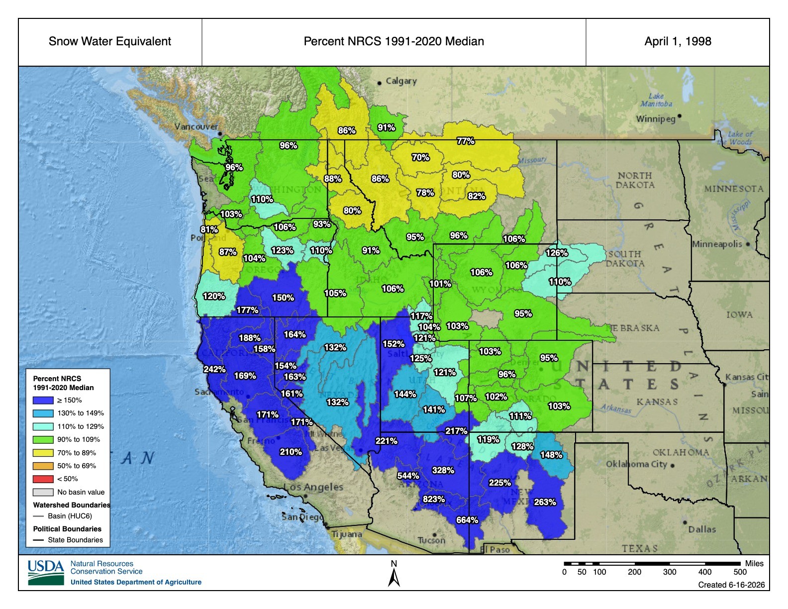
Another super El Niño season came in 1997–98, which similarly saw huge snowfall numbers for California and the southwest, including most of Utah.
Nobody is promising a repeat. Climate forecasting three seasons out is still closer to educated guessing than to a weather app, and even NOAA's forecast is a probability, not a guarantee. But when the setup looks this loaded, it's fair to let yourself get a little excited.
The Bottom Line
Southern Utah should be feeling very good about its odds heading into 2026–27. Northern Utah's forecast is a little more "trust the process" — a potentially slow-loading November and December, with real reason to believe things turn on later in the season, and a nonzero chance this ends up being the kind of winter people are still talking about in 2050.
Either way, it's never too early to start the snow dance. Just maybe don't park on State Street come May.