As Utah skiers and snowboarders, we have a certain expectation as to how much snow we should get during the winter season. Hint: We expect A LOT of snow. Thanks to long periods of record-keeping at our resorts, we generally know what our “average” snowfall is. It’s easy to compare it to what we actually receive. Then, we slap on a generic summary of the season -- “That was a great year!”, or “That season was a bad,” or “Last year was average.” Over the past 10 years, we’ve seen several above-average years, and several below-average years, but it’s been awhile since we’ve had a season that was just about “average.” Well, this year was “average”—at least from a statistical perspective. But for anybody who spent the season riding in Utah, it was anything but “normal.”
The first half of this season was glorious by any skier’s standards. We had a bit of a slow start in early November, but Mother Nature blessed us with a strong storm cycle to end the month and we received up to five feet of snow during Thanksgiving week. Southern Utah, in particular, saw a very strong late November and early December. Northern Utah also received consistent snowfall through December. As the calendar flipped to 2020, we were sitting pretty with an above-average snowpack.
This healthy snowpack set the stage for what I consider to be our best storm cycle of the season in mid-January. A series of cold systems impacted the region and brought up to 95 inches of The Greatest Snow on Earth to northern Utah mountains. Here is a chart of the totals for the week (in inches of snow):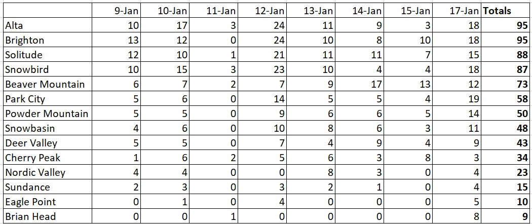
At this point in the season, we were well-above average snowpack and it seemed like the powder days were just stacking up one after another. It was looking like Utah was destined for another epic season.
Then, things started to get strange in February. We started the month with a relatively small, but cold system. Normally, this wouldn’t be of much interest. However, it was followed by a very large, and warm storm system that dropped up to three feet of very dense snow on top of the sugary, low-density snow from the preceding storm. Typically, Utah sees right side up snow with the lightest, fluffiest snow on top. In this scenario, however, it was upside down. This created unstable snowpack conditions. Subsequently, Little Cottonwood Canyon had its longest interlodge ever – Alta Ski Area and Snowbird were unable to open for two days as avalanches rushed down the mountainsides and covered the highway.
What is interlodge you ask? Interlodge means that the avalanche danger is so high that guests and employees of the resorts are mandated to stay indoors while avalanche control work is performed and until it is safe to resume activity outside. Guests may not seek shelter in their vehicle and in many cases, travel between buildings is not permitted. Safety is always the first priority and buildings in these areas have been designed specifically to withstand such conditions. We look at it as a chance to catch up on emails, social media and make some new friends! And when the interlodge is lifted? Get ready for some of the best powder turns of your life if you were one of the lucky ones interlodged up the canyon. The first few hours after an interlodge is lifted is oftentimes referred to by the locals as "country club" skiing, because those who are already staying slopeside get to the powder turns first, and enjoy a couple of solitary hours on the slopes before the rest of Salt Lake City makes it up to the mountain.
Despite the unusual storm and circumstances of early February, our snowpack continued to look fantastic with widespread numbers well-above average.
High pressure took control in February and the frequent storms ceased for a while. At first, we weren’t too disappointed, we had bluebird sunny days and an opportunity to dig out. But the storms took longer than expected to return and we started March relatively quietly. Our snowpack numbers remained above average, but they were not quite as impressive as they were in early February.
Everything changed in mid-March, the COVID-19 pandemic gripped the world. Ski resorts here in Utah, and across the globe, stopped spinning their lifts in an effort to slow the spread of the disease. It was an unexpected and unfortunate end to the season for most of us. It has also been a sobering reminder not to take what we have here in Utah for granted. We are blessed with abundant snowfall and unparalleled access to the mountains. When that is taken away unexpectedly, it makes you truly appreciate how lucky you were to have it in the first place.
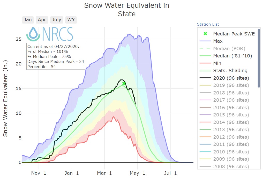
Here is the statewide average snowpack for the season:
This season (black line) was tracking above the median snowpack (green line) for most of the year. Then, in mid-February, we saw the snowpack start to regress back toward average. We did see a bit of a late-March bump after the ski resorts had closed. This ensured that we finished the season slightly above average.
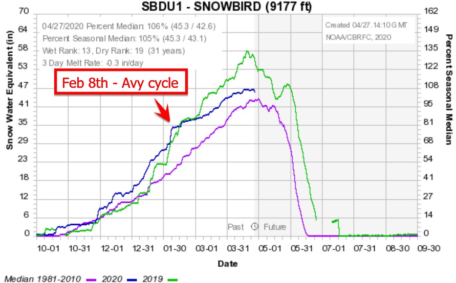
The Snowbird Snotel station in Little Cottonwood Canyon is the snowiest (on average) in the state. If we look at that location, we can see that the numbers we even more impressive mid-season, before slowly returning to “normal”:
The green line in the above graph is last year. If you remember, last year we topped 700 inches of snow in Little Cottonwood Canyon. This year, we were actually ahead of last year’s pace in early February, but then were drier than normal in February, March and April. In the end, LCC finished the season slightly above average with upwards of 540".
If there is a silver lining to our unprecedented end to this season, it’s this. From a weather perspective, the far more active and snowy portion of the season was during the first half. Our best powder days occurred long before any of us had ever heard of “social distancing”. This is the portion of the season when the sun angle is lower and the powder stays fresh for longer. We may not have had the end to the season that we were hoping for, but the first three months of this winter were incredible, and nobody can take that from us.
2019-20 Season Wrap-Up
By Yeti
May 5, 2020
A review of the 2019–20 ski season including snowpack, storms and the longest interlodge on record.
.PNG/inline-display)
